Experience Norfolk by bike

A spin along the tranquil lanes reveals quaint timeless villages, peaceful wildlife havens and buckets of quirky charm, from prehistoric mammoths to steam railways.
You’ll find medieval churches full of original carvings and paintings, or barns of the same age that are now bat sanctuaries. Glide through the gently rolling, minimal traffic ‘Quiet Lanes’, follow single track paths through timeless woods, stop to watch swans on secret inland lakes, or ride alongside deer in the evening sun.
While it’s not actually totally flat, gentle gradients mean the riding is easy and legs last longer so you can cycle further and see more – or just let the relaxed pace of the region guide you on a serene glide.
When you need to feed your appetite, surrender your taste buds to scones in the gardens of sumptuous Tudor stately homes, fine local produce in farm shops, or freshly landed crab at Cromer all in the same ride.
When you’re done exploring for the day, you can choose from an equally eclectic mix of places to stay: from campsites to youth hostels or hotels where aristocrats and royals once stayed.
We’ve aimed to keep our routes to a leisurely distance, but there’s potential to expand each one to take in even more treasures of Norfolk.
Head further east along the coast past nature reserves, or towards Aylsham to link between our two EXPERIENCE hubs in Cromer and Wroxham/Hoveton.
You could link up a whole string of grand stately homes, or just enjoy the woods filled with birds or big sky landscape free from the usual troubles of traffic or tiring hills.

Wroxham & Hoveton
The ‘capital of the Broads’ has a medieaval heart that has flourished as a boaters’ paradise with a real ‘seaside’ vibe. The lack of hills and some of the best weather in the UK mean it’s also a perfect base for restful riding around the unique wetlands ecology and multi-faceted history.
The villages of Wroxham and Hoveton sit either side of the river Bure north-east of the stunning and fascinating city of Norwich, but they’re a bustling holiday hub in their own right. The Norfolk Broads landscape mixes backwaters teeming with birdlife, ancient churches and country pubs in charming thatched and flint cobbled villages for a timeless riding experience that won’t tax your legs.
Our three routes link cathedrals, castles, steam railways, radar museums, Roman remains, breweries boat houses and famous RAF airbases with cycle paths, historic byways and quiet roads to make the most of this magical part of the UK.

Wroxham & Hoveton essentials
Hoveton is the bigger half of the village on the north-east bank of the river Bure. It’s an ancient bridge/ford site with 12th century elements to the church, but came to prominence as a trading centre in the medieaval period.
The arrival of the railways saw river transport turning mostly from business to pleasure with traditional sailing wherries and then purpose built cruising boats opening up this amazing wetland area for holidaymakers.
The Roy family set up a small shop to supply boats in 189,5 but their local empire now extends to several large shops, a garden centre and a garage, all under the slogan ‘The world’s largest village store’.
Wroxham miniature worlds is also the biggest indoor model attraction layout in the world, and Roarr dinosaur world and the Bewilderwood attractions are close by if you’re riding with youngsters.

Getting there
By train Hoveton station is 14 minutes from Norwich on the Greater Anglia Cromer line.
By road Wroxham/Hoveton is 4 miles off the A1270 Norwich ring road on the A1151.
Routes

Norwich railway ramble (47 miles)
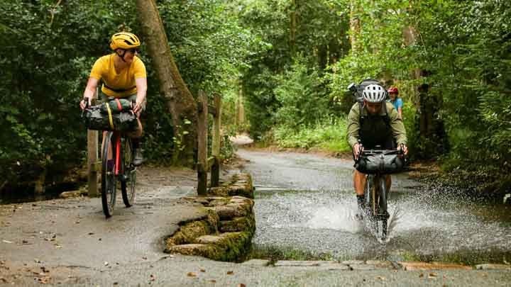
This route is best tackled on a gravel bike or tourer/hybrid/MTB with wider tyres. That’s because it steams out into the peaceful countryside west of Hoveton on old railway lines, but it would be easy to shadow on quiet lanes if you want firmer surfaces.
Taking the trail option makes most of the loop blissfully traffic free and keeps navigation super simple for the first 55km. It also allows you to really drink in the timeless landscape of wide open farmland past wildlife-rich woods, winding rivers and flower filled meadows.
As well as miniature train lines and old stations, you’ll also pass a wide range of historical sites from ancient to modern, before arriving at the beautiful richly storied city of Norwich. A perfect place to stop and explore before the short quiet lane and byway ride back to Wroxham.
Barton Turf (17 miles)
Another figure of eight route (actually it’s more like a badly melted snowman) that allows you create a shorter option. A total ascent of just over 110m and high point of 16m means it can be as easy as you want to make it too.
With miniature railways, reed beds, blissfully idyllic villages, a craft centre, and the radar museum at Neatishead all on route, there’s plenty to take your time over. There’s also the option to cross the River Bure at Horning and join our Ranworth Broad route if you’re lucky enough to find the foot ferry running. This route is entirely on road so any bike will be enjoyable.
Ranworth and Malthouse Broads (18 miles)
This roughly figure of eight route takes you south and east of Wroxham, skirting the Broads that you can walk to the edge of from several points.
It’s mainly a very quiet road loop that can be done on any bike, but we have included a couple of short farm track sections which will need care - or bypassing - on narrow tyres.
The short loop includes an award-winning brewery, several pubs, and beautiful churches including a dramatic ruin, as well as stunning thatched cottages and barns in picture-perfect villages.
There’s also the opportunity to cross the River Bure to Horning when the small ferry is running, which allows you to join the Barton Turf route north of the Broads.
Either way, it gives you a fantastic taste of this unique and charming landscape with its easy rolling roads, rich wildlife and history.
Cromer
With a fabulous Victorian pier and seafront architecture to match, Cromer is the perfect example of a traditional English seaside resort and thoroughly deserves its ‘Gem of the Norfolk coast’ tag.
Sitting at the heart of the Norfolk Coast Area of Outstanding Natural Beauty with its long beach flanked by rich cliffs and backed by wooded hills, Cromer stands out immediately in terms of geography.
The surrounding area has an equally distinct historical and natural character too. From the nature reserves, creeks, flint wall architecture and bright boats of Blakeney, to the military vehicle collection at Muckleburgh, or the mammoth mural promenade of Sheringham and the cliffs of Runcorn which regularly cough up prehistoric animal remains, there's a wealth of fascinating quirks to explore.

Cromer essentials
While there are prehistoric remains in the area and a Roman camp overlooking the town, Cromer itself doesn’t appear in records until the 14th century. That’s because the coastline is so changeable here that the previous settlement of Shipden is now under the sea several hundred metres beyond the end of the pier.
While the fishing village of Cromer became popular with local visitors through the 1700s and 1800s with some hotels from that date still surviving, fishing remained the mainstay of Cromer’s economy until the later Victorian period. That was when new railway connections saw droves of visitors coming to enjoy the long sandy beaches, splendid pier and seafood - including the famous Cromer Crab.
That delicacy as well as lobsters and other shellfish are still the main trade of the dozen or so boats still fishing from the shallow beach. Others now head out to sea to see the 20 mile long Cromer Shoal, a chalk reef dating back to the Pleistocene era and an incredible place for diving and snorkelling.
The cliffs of the ‘Deep History' coastline are also famous for prehistoric animal remains, including the remains of the largest mammoth found in the UK and an Ice Age rhino.
The pier - with its Pavillion theatre and famous lifeboat station - has survived many storms and even a plan to blow it up in the face of imminent invasion in World War II. It forms the centrepiece of the recently refurbished promenade area below the fantastical frontage of the Hotel De Paris, which serves as the starting points for all our rides.

Getting there
Take the ‘Bittern Line’ railway service from Norwich which has mainline connections to London Liverpool St, Cambridge and Peterborough.
By road, Cromer is 23 miles from Norwich on the A140 or 44 miles from Kings Lynn in the west on the A148. Be prepared to be patient though as Norfolk roads run at a relaxed pace.
Routes

Cromer roamer (40 miles)
The longest of our three Cromer routes takes you up over the hill behind town past the South American themed Amazona zoo, before rolling majestically through the National Trust parkland of Felbrigg Hall.
It continues effortlessly out through historic villages and farms offering fresh produce on almost totally traffic-free roads beneath vast skies.
You turn north though the bustling market town of Holt, then climb gently on rarely used rolling lanes before dropping to the coast at Blakeney.
From here, you daisy chain back towards Cromer, linking totally different versions of the Norfolk coast at Weybourne and the busy seaside town of Sheringham via inland loops through heath and woodland, with stories stretching back many millennia, before reversing the start back into Cromer.
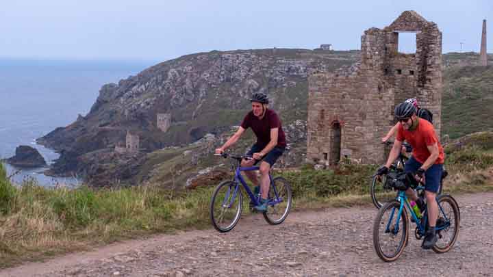
Great Wood gravel ride (18 miles)
Our off-road loop takes you out through the woods past Amazona Zoo, before looping south through the beautiful grounds of Felbrigg Hall.
You then switch from Tudor splendour to off-road adventure as deserted back lanes past medieaval farms become gravel and grass bridleways swinging round up to the north again, where you’ll wind through the woods towards the kind of panoramic hilltop coastal view you’d never expect in Norfolk.
There’s even a short but sweet technical descent before you contour back into Cromer on a mix of snaking singletrack, pasture side path and a scenic golf course.
Mundesley meander (20 miles)
This southerly route rolls gently out through the quiet but genteel village of Overstrand, across the coastal Poppylands with their 360º vistas, to the seaside village of Mundesley with its much more lively feel, beautiful Blue Flag beach and rows of colourful huts.
You loop inland past a preserved windmill and huge medieaval barn that’s now a bat sanctuary, into an area of dedicated ‘Quiet Lanes’. Then it’s a parade of ancient carving covered churches in similarly quaint villages with flower filled gardens and honesty boxes for handmade jam joining the dots back into Cromer.

Diss
Diss sits on the Suffolk border in a rich farming and forest landscape well away from the busier broads and north coast.
While there are some busy main roads in the area, we’ll take you along tranquil back roads and designated ‘Quiet Lanes’ where cars come second to riders, walkers and cyclists. The lack of hills in the area means the miles come easily too, making it ideal for riders of any fitness level or experience.
Surprisingly Diss doesn’t have much early archaeology, but as the Anglo-Saxon name comes from ‘ditch’ or ‘rampart’ and the way it rises above the surrounding land definitely suggests this was a significant defended site in earlier times. It’s only a handful of km east of ‘Pye Road’ which dates from at least the Roman period when it was the route taken by Celtic Norfolk Queen Boudicca on her way to destroy Colchester, St Albans and London. The area - including nearby Thetford - was very important throughout the post Roman, Anglian, Saxon and Viking periods and was a Royal ‘hundred’ by the time of the Norman invasion and the Domesday book.
It continued to grow in prosperity throughout the medieval period with the Friday market first given a charter by Richard the Lionheart. Architecturally much of the town is Georgian and while - like a lot of Norfolk - its fortunes ebbed in the last couple of centuries it’s revived dramatically in recent years. That included the cleaning up of the beautiful ‘mere’ in the centre of the town and a more gentrified, independent shopping and foodie environment. This small south Norfolk town also gained worldwide fame when Hip Hop superstar MC Hammer came to the same conclusion in his smash hit “You can’t touch Diss”. The local Corn Hall theatre still punches way above its weight in terms of visiting performances too.
Diss essentials
For a small town Diss has a really good range of amenities and shops. Delicatessens like Benedikts and Anandines plus a wide range of restaurants from traditional to boutique and worldwide make it easy to find a place to eat and there are lots of takeaways as well. There’s a decent range of accommodation locally too, although most places are in the surrounding area rather than town itself.
Madgetts Cycles or the Cycle Shack can take care of most bike maintenance or forgotten bits and pieces and there’s a Screwfix if you need more general tools. Tesco and Morrisons superstores south of the Mere should cover most food and grocery essentials and there are several pharmacies too. There’s a leisure centre with a pool as well. The local theatre is a thriving cultural centre, often hosting significant performances from big names.
Getting there
If you’re heading to Diss by train it’s a 90 minute journey on the Norwich line from Liverpool St station in London. Alternatively, you can route to Norwich from Peterborough on the east coast mainline and then jump onto a train south to Diss.
Driving from the south take the M11 then A11 to Thetford and then follow the A1066 east to Diss.
From the midlands head for Cambridge and then join the A11 to Thetford
From the north head for Kings Lynn and then follow the A10 and then A134 to Thetford.
Routes
Sands and trees (48.5 miles)
Zoolander (20 miles)
Two churches (15.5 miles)
Explore the routes
Discover Wroxham & Hoveton
Norwich railway ramble (47 miles)
Barton Turf (17 miles)
Ranworth and Malthouse Broads (18 miles)
Discover Cromer

EXPERIENCE is a €23.3 million project co-financed by the European Regional Development Fund (ERDF, €16 million) through the Interreg VA France (Channel) England Programme 2014-2020, boosting visitor numbers in six pilot regions across England and France. This project will harness the experiential tourism trend to extend the season (October – March), generating 20 million new off-season visitors spending €1 billion across the Channel region by June 2023.